
Shortly after starting Artwave in 2019, we became a husband and wife team.
In the last five years, we built a home and a company, but what about our bodies? With a love for the outdoors, we set out to walk more.
Whenever you see this sign 📍, you can search the walk in the AllTrails app, which we use to navigate all our hikes.
To date, we have walked over 800km in New Zealand.

📍 Redwood Memorial Grove Walk → 1.9km → 58m Elevation gain | A short forest walk amongst giant redwoods. Look at how tiny we are!

📍 Okere Falls Track → 2.4km → 67m Elevation gain | A short waterfall walk with a small cave to explore.

📍 Mount Maunganui Summit → 3.9km → 207m Elevation gain | Our first summit on an extinct volcano along the coastlines.
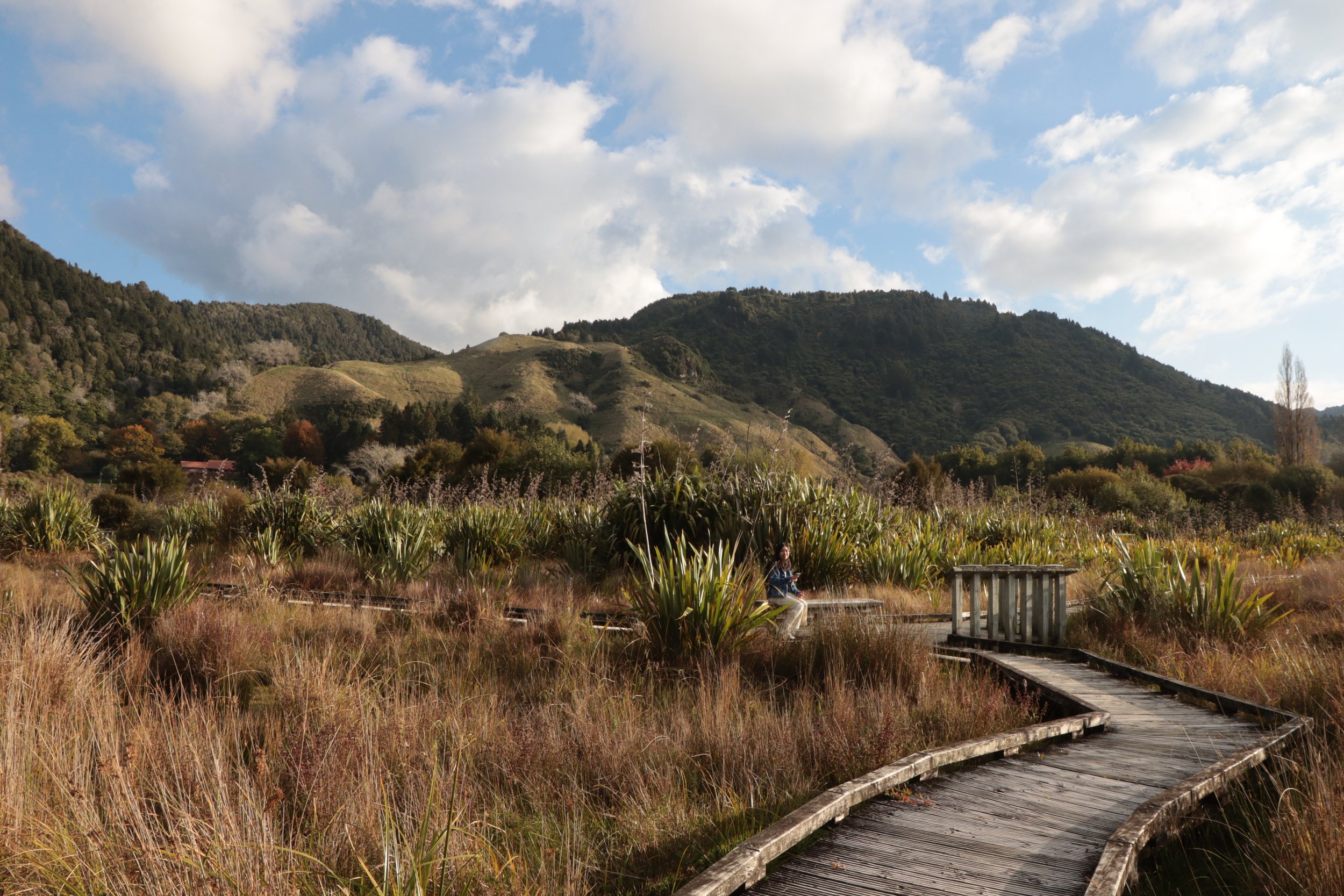
📍 Lake Okareka Walkway → 5km → 46m Elevation gain | Our first wetland walk. Birds of every kind, and views of the lake at every turn.

📍 Spa Park to Huka Falls Walk → 6.9km → 173m Elevation gain | We're learning to cover more distance. This one followed a river so blue, that ended in a waterfall.

📍 Taranaki Falls Walk → 6km → 145m Elevation gain | Our first walk in the Tongariro National Park. It was a volcanic landscape, earthen and raw.

📍 Te Auheke Track (Cascades Falls) → 1.3km → 72m Elevation gain | A very short and relaxing walk to a waterfall that must have inspired indoor waterfall walls. We're reminded that not all beautiful views are difficult to get to.

📍 Rainbow Mountain and Crater Lake Outlook Track → We had hoped to see two crater lakes. But the viewing points were closed. Caught a glimpse between trees instead. We did not complete the track.

📍 Queenstown Hill Walkway → 4.8km → 399m Elevation gain | The toughest, most relentless hike so far. Felt the push in our legs as we inclined and learnt to regulate our breathing uphill!

📍 Moke Lake Loop Track → 6.9km → 173m Elevation gain | A single file track with constant views of the lake and surrounding mountains. Like walking in The Lord of the Rings movie set. The distance was getting manageable for us.

📍 Arrow River Bridges Trail → 4km → 63m Elevation gain | Late April. An easy, flat track blooming with the last of the autumn's colours.

📍 Wye Creek Track to Helicopter Landing → 4km → 332m Elevation gain | A thrilling hike on water pipes leading to a helipad. We got lost a few times, but finished with a banana on top.

📍 Sealy Tarns Track → 5.3km → 546m Elevation gain | Dubbed the “Stairway to Heaven”, we climbed 2,200 stairs to the freshwater lakes of Mount Cook National Park. The views were unlike anything we’ve seen before.

📍 Tasman Glacier View Track → 1.3km → 82m Elevation gain | A short walk to our first ever view of a glacier.

📍 Hooker Lake via Hooker Valley Track → 10.9km → 197m Elevation gain | Our longest distance covered so far. Crossed three swing bridges suspended over glacier lakes to this breathtaking view of Mount Cook.

📍 Mirror Lakes → 0.3km → 3m Elevation gain | Our first walk in the Fiordland National Park. Albeit short, it made us want to return to hike all the other tracks.

📍 Routeburn Track: Routeburn Shelter to Routeburn Flats Hut | The start of one of New Zealand's Great Walks. It would have gone on for 3D2N, but we only tried the first hour!

📍 Glenorchy Lagoon Walkway → 3.4km → 33m Elevation gain | We don't get to choose how the sun shows up. A gloomy day calls for a peaceful wetland walk.

📍 Jack’s Point Track → 14km → 467m Elevation gain | Walked into a golf course as part of the track. Didn't want to get hit by a golf ball, so we skipped the last part.

📍 Bob's Cove Track → 10.6km → 249m Elevation gain | All kinds of mushrooms littered this forested trail. Our first time seeing a cove from a vantage point!

📍 Bannockburn Sluicings Loop → 3.9km → 142m Elevation gain | The strange shapes in this arid landscape were carved out of human mining activity in the 1900s.

📍 Sawpit Gully Trail → 7.9km → 412m Elevation gain | Not far from Queenstown, we decided to revisit Arrowtown's autumn changes.

📍 Lake Wānaka Lookout Track → 5km → 275m Elevation gain | Came across a hidden lake that would freeze into a winter ice skating rink back in the day.

📍 Bennetts Bluff View Point Walk → 0.6km → 17m Elevation gain | A very short walk off the highway to Glenorchy.
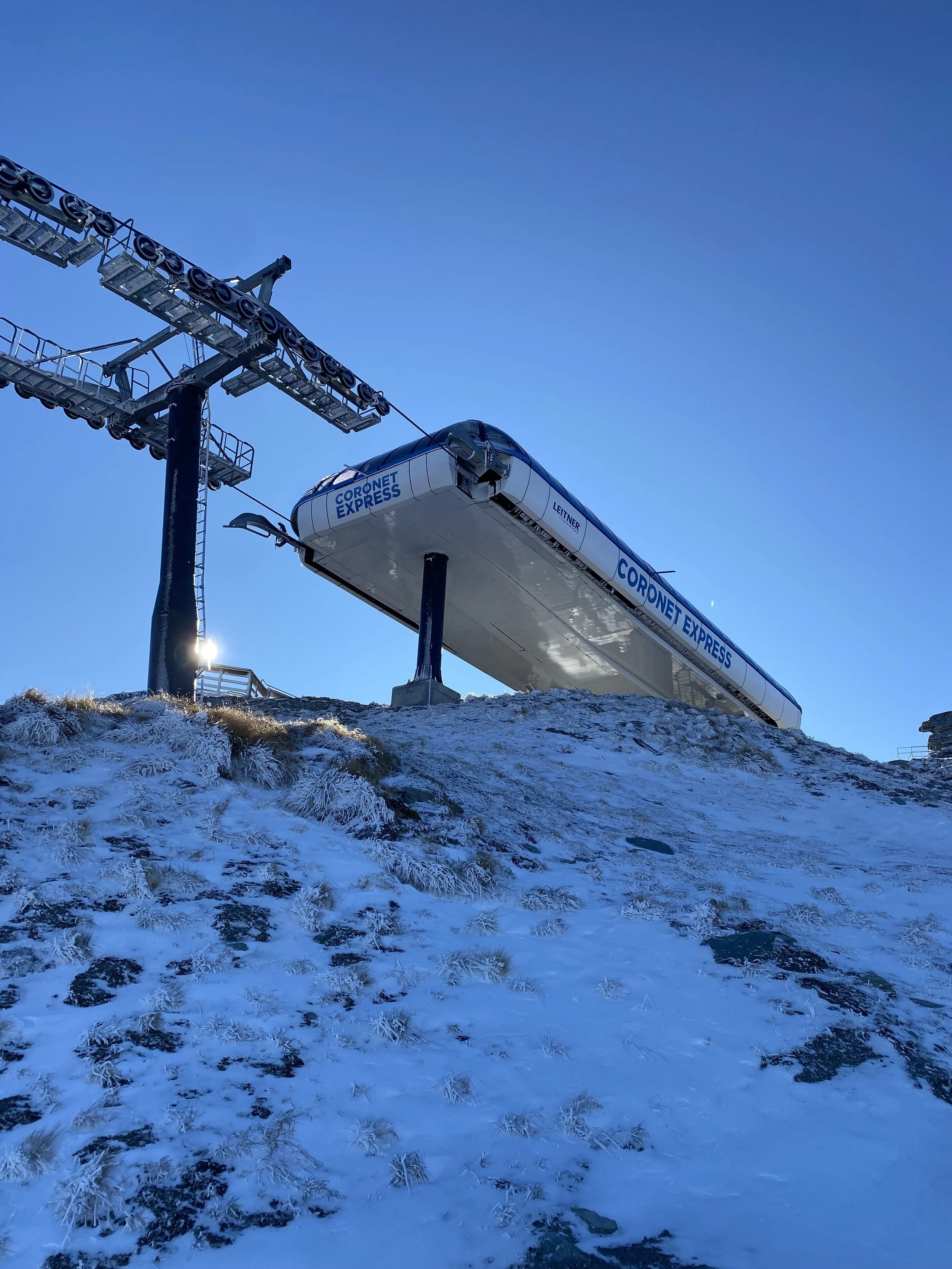
📍 Coronet Peak → Snow was beginning to form on the mountains. We didn't know how much distance we covered, because all we wanted was to reach the top of the ski station.

📍 Lake Dispute Track → 6.1km → 292m Elevation gain | A final training track for the bigger walks we are about to do in the national parks!

📍 Lake Marian Track → 6.1km → 400m Elevation gain | We headed down to the Fiordland National Park again. This was one of the best hikes we found in the area and it was challenging. Climbed robust tree roots and were so impressed with how these roots turned into steps and ladders for hikers overtime.

📍 Key Summit and View of Lake Marian via Routeburn Track → 8km → 433m Elevation gain | The other end of the Great Walk. We met hikers who completed the 3D2N journey. They were over 60 years old, and incredibly inspiring for getting to the end.

📍 Queenstown Gardens Loop → 1.9km → 13m Elevation gain | A garden by the mountains during sunset.

📍 Lake Hayes Walkway → 7.9km → 123m Elevation gain | There are so many ways to walk a lake. One of the most common ways is around it. So around we went.

📍 Whiteireia Park Loop → 6.6km → 80m Elevation gain | Our first walk in Wellington, the capital of New Zealand.

📍 Colonial Knob Walk → 3.5km → 256m Elevation gain | This city is windy and seems to have an overcast on most days.

📍 Paekakariki Escarpment Walk → 9.85km → 358m Elevation gain | This coastal walk could be done in one direction, then hop on a train back. The long swing bridges were impressive.
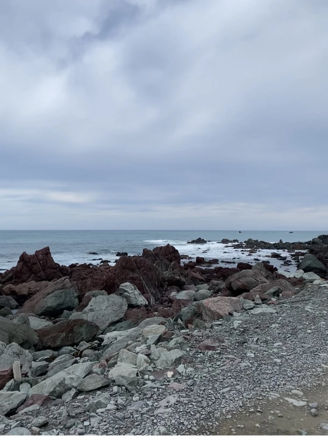
📍 Red Rocks Coastal Walk → 7.6km → 136m Elevation gain | A surprisingly challenging walk to navigate due to the rocky ground. We were mostly looking down, making sure to put our foot on the right step.
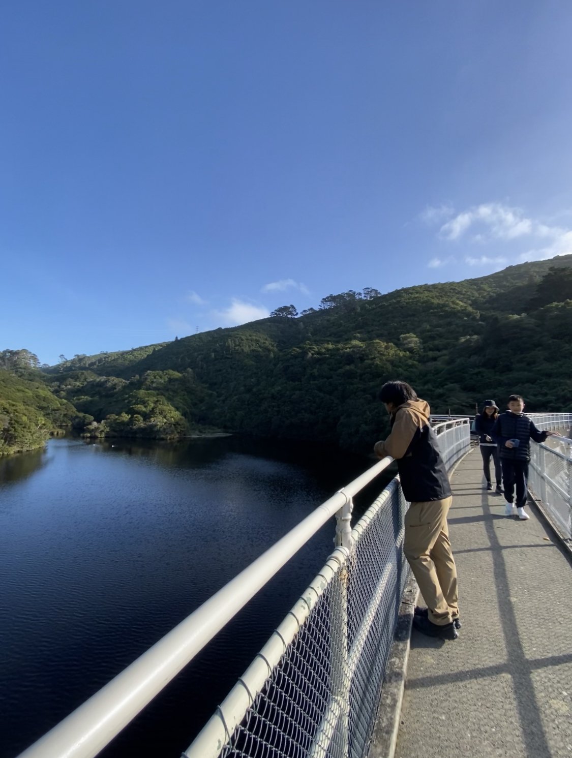
📍 Zealandia Te Mara A Tane — Round The Lake Track → 4.8km → 140m Elevation gain | Our first paid walk in a forest. We learnt to spot birds like the Kereru - a pigeon with a large white chest.

📍 Titahi Bay Beach and Stuart Park → 3.2km → 38m Elevation gain | Spotted many tiny, cute fantail birds on this track.

📍 Camborne Walkway → 4.3km → 12m Elevation gain | Lots of baches (weekend cottages) along this track. Summer must be filled with activity here.

📍 Te Ara Piko - The Meandering Path Walkway → 9.2km → 48m Elevation gain | We were right by the roads most of the time. There were birdwatchers throughout the trail. It was a co-existence of wetland nature and roads.

📍 Rivendell Walk → 0.5km → 8m Elevation gain | This was the entrance to Rivendell in Lord of the Rings. The rest of the set had already been torn down.

📍 Motueka Inlet Walkway → 4km → 26m Elevation gain | Exploring a new town.

📍 Kaiteriteri to Stephens Bay Walk → 5km → 97m Elevation gain | A coastal walk with golden sand.

📍 Wai-iti River Walk → 5.1km → 63m Elevation gain | Exploring a part of Tasman's Great Taste Trail for cyclists.

Shedwood Bush Track → 6.3km | We couldn't find much information on this trail so we left a Google review for it. It was slippery, but rewarding.

📍 Mount Robert Circuit → 8.5km → 636m Elevation gain | We started the day slightly late, knowing full well that the sun would set at 5pm. Took the advise of other hiker reviews and went in the anti-clockwise direction. The views kept getting better and we walked along a mountain ridge for the first time!

📍 Hawkes Lookout Walk → 0.8km → 18m Elevation gain | A kid coming out from the walk warned us about dinosaurs.

📍 Te Waikoropupu Springs Walk → 1km → 11m Elevation gain | The clarity of the water allowed you to see through the depth of the springs. How pure!

📍 Wainui Falls Track → 3.4km → 96m Elevation gain | A 20-metre high waterfall in the Abel Tasman National Park.

📍 Motueka Beachfront Track → 8.2km → 70m Elevation gain | One of us lost our sunnies on the way so we kept tracking back and forth the path. Thankfully a kind soul placed it on top of a post.

📍 Brightwater Loop Track → 8.7km → 89m Elevation gain | We are getting used to doing a longer distance now!